COMPUTER VISION
PETROAI .
PetroAI is the world’s first, AI-driven lithography classification platform for geoscientists, that helps industry users increase the service efficiency and productivity of their critical oil and gas assets.
Crafted by an experienced team of AI engineers and internationally-renowned geologists, PetroAI was created with a vision to offer a cognitive geoscience ecosystem that helps users visualize and learn from disparate data sources. With a lethal combination of data analytics and industry expertise, now you can leverage the power of data science to improve oil and gas workflows.


NEED OF PETROAI ?
PetroAI eliminates the need for tedious and labouring methods to examine assets during the process of oil drilling, and enables on-site geologists with visual data to determine a comprehensive valuation of discovered assets. Not just that, PetroAI overcomes the barriers of non-digitization of images and lithographic descriptions to eliminate inconsistencies and unavailability of data for any future analysis.
Our portable geoscience PODs offer ease of mobility, while our onsite, real-time analysis of rock samples reduces the need for exhaustive lab tests to determine properties. In addition, the knowledge base of experienced geologists gets imbibed in the algorithm, thereby preserving expertise that geologists have spent decades developing.
OUR SOLUTIONS.
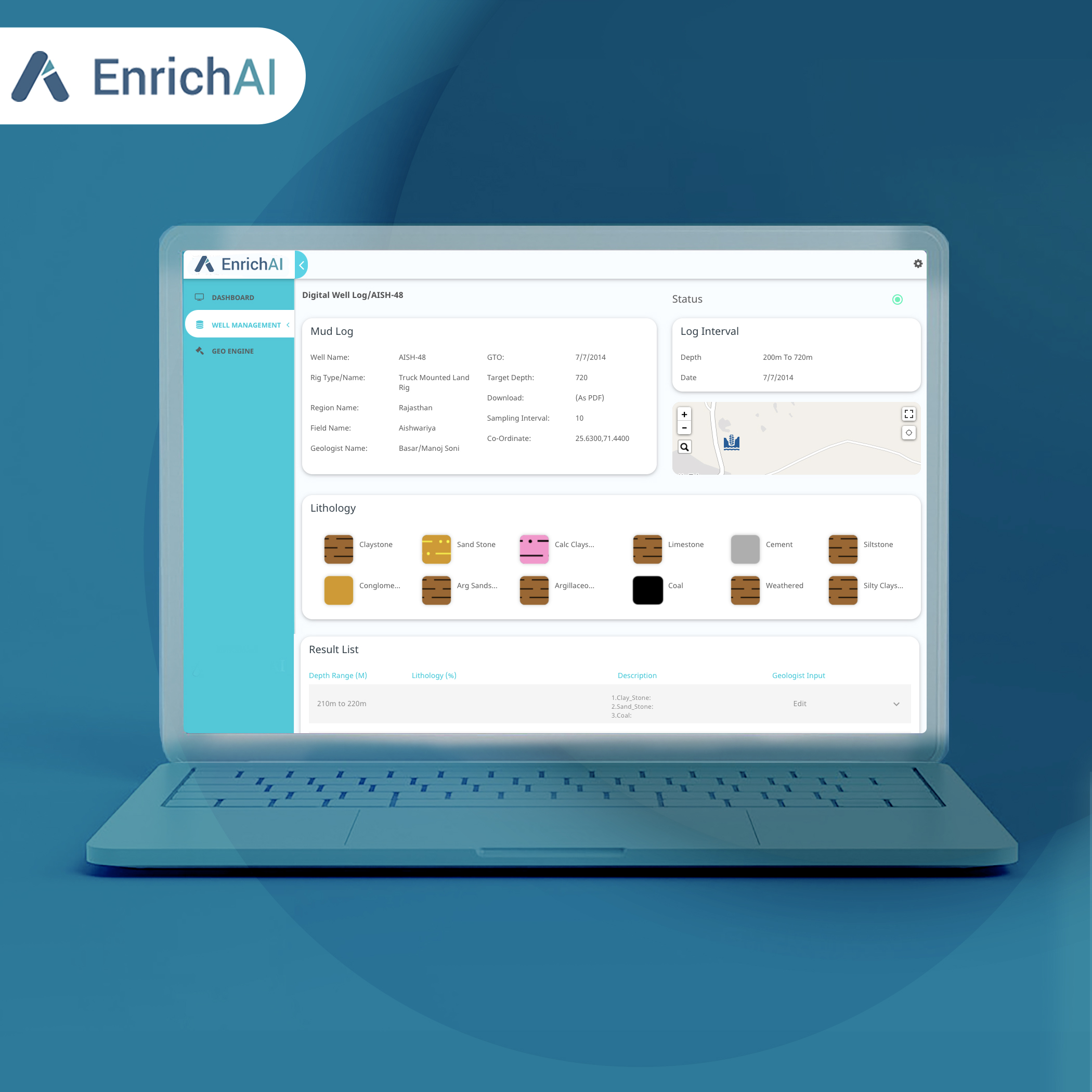
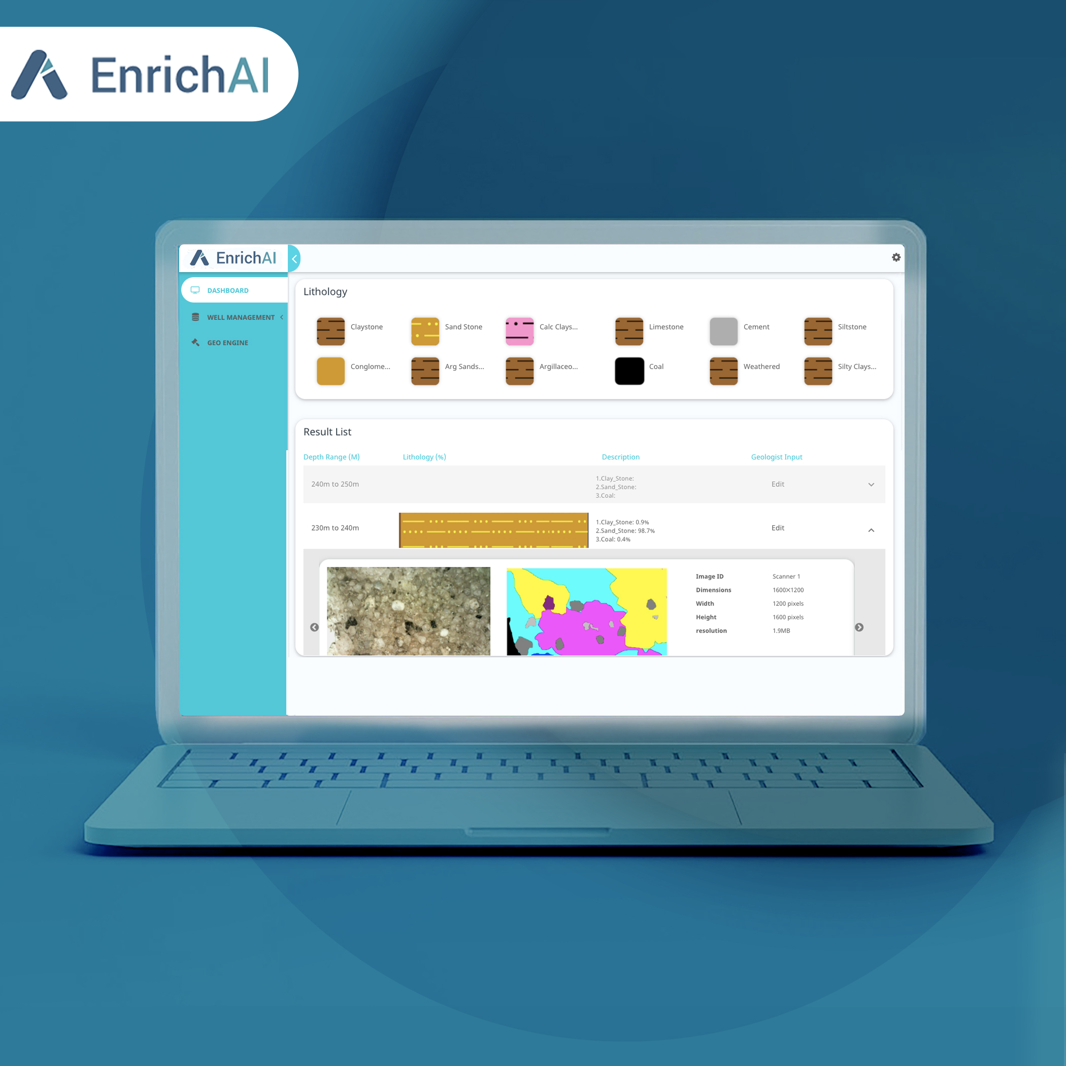
Our comprehensive geo-science suite captures images of cutting samples in controlled lighting conditions, processes the image, compares it with thousands of other pre-annotated images, and runs it against our proprietary computer vision algorithms to generate an automated lithography classification of the sample in less than 60 seconds. The image and the lithography description can then be visualized through a cloud-based web interface to effectively monitor development and performance.


COMPONENTS.
Geoscience Pod made with industry-grade hardware, which is -
- Portable (similar to size of a microwave).
- Has robust housing for sample placement.
- Offers high optical resolution.
- Offers actuated illumination.
- Provides seamless connectivity on cloud platform through ethernet and cellular connectivity.
Geoscience Hub with extensive monitoring capabilities that offer -
- AI-powered cutting sample description with more than 80% accuracy.
- A digital well log with easy-to-interpret formations and trends.
- A Dashboard to check real-time status of ongoing processing.
- A collaborative feedback platform that automatically archives digital images of samples for future analysis.
FEATURES.
- Hydrocarbon module that detects the presence of hydrocarbons by imaging processing.
- Lithography module that detects and classifies over 9 types of rocks bases on :
- Rock Type
- Angularity
- Sorting
- Our platform is 20 times faster than manual description.
- It has been trained on more than 5000 sample images of over 20 wells.

WHO WILL BENIFIT ?
- Upstream Oil and Gas Companies who will be able to generate real-time and accurate description of cutting samples in an automated manner. Our solution will also on-site geologists to quickly make data-driven decisions.
- Field Service providers, who will have access to a digital platform that stores all information of cutting samples, along with their detailed properties, for current anf future analysis.
OUR CUSTOMERS.
AWARDS.